Thursday, June 5, 2014

Controlling the Quad Copter

Controlling the Quad Copter

Figure 4.4 Controlling Quad copter
When a rotors turn, it has to overcome air resistance. The reactive force of the air against the rotor causes a reactive moment called the “Induced moment”. The induced moment acts on the rotor in the direction opposite to the rotation of the rotor.

As everyone knows, conventional helicopter require the tail-rotor to counteract the induced moment, in the hover both sets of diagonal rotors turn in opposite directions (as indicated by the opposite direction of the arrows in Fig.)

As long as all rotors experience the same induced moment which is mostly a function of speed of rotation and rotor blade pitch the sum of all induced moments is zero and there is no horizontal rotation. If one set of rotors, for example the one that turns counter-clockwise in fig., increase their rotational speed or their pitch, the resultant net induced moment will cause the quad copter to rotate clockwise.

It is important to note that because of the diagonal arrangement, this operation has no effect on translation in x or y direction. The effect on up/down motion can be compensated by reducing the pitch speed of the other diagonal pair, although in practice this is not quite so easy without some sort of feedback control.

Monday, June 2, 2014

Schematic Diagram of Aerial Reconnaissance Robot

Schematic Diagram of Aerial Reconnaissance Robot

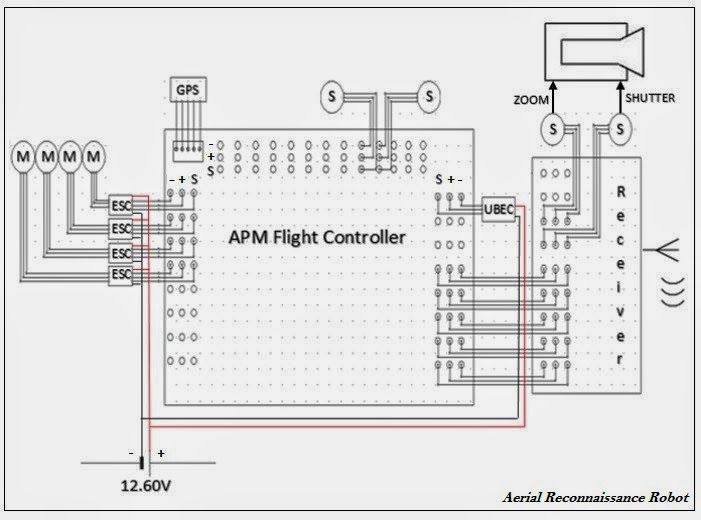
Figure 4.3 Schematic Diagram of Aerial Reconnaissance Robot

     Figure 4.3 presents the schematic diagram of aerial reconnaissance robot’s main circuit. The APM is the central component of the system. The receiver manages the signal coming from the route controller, then it feeds the signal to the APM, then the APM controls the servo for the camera, to be able to control the motor the APM feeds the signal to the ESC, the ESC controls the motor for steady flight.

System Flowchart

System Flowchart

System Flowchart

System Flowchart

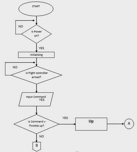
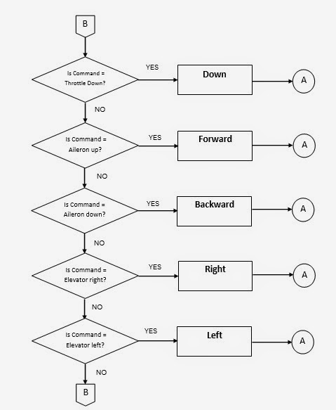
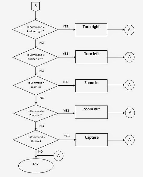
Figure 4.2 The System Flowchart

     Figure 4.2 indicates what will be the movement of the quad copter once the input command initialize. The flight controller tells which motor will increase the power that will create movement of the quad copter. The motor will response either left, right, rotate left, rotate right, up, down, forward and backward. The output will be dependent on the RF controller. The expected movement of the quad copter and camera will be executing once the signal was sent. And once the signal was received by the RF controller, the program will analyze the receive data and it will automatically send the requested command to be performed.


Sunday, June 1, 2014

System Block Diagram

SYSTEM DESIGN AND CIRCUITS ANALYSIS

This chapter contains the system design, circuits, diagrams, discussion, computations and components.


System Block Diagram

     Fig. 4.1 shows the flow of the project from input to output. The transmitter board gives the command that will be received by the receiver board. The receiver board will give the received command to the APM flight controller, it will be read by the flight controller and it will distinguish where that command is for, if for the GPS, Camera gimbal or Electronic Speed Controller. If the command is for the DC motors the flight controller will send the command to the Electronic Speed Controller (ESC) to regulate the speed of the motors to make it move sideways, forward, backward and turn. If the command is for the Camera gimbal the APM will send it to Camera Gimbal that will make it to tilt and be balanced. The GPS feeds information, like coordinates and more to the APM flight controller.

System Maintenance, Method of Data Collection and Research Locale

System Maintenance, Method of Data Collection and Research Locale

System Maintenance

The proponents need to maintain the system by checking all the materials before and after the flight and test flight to avoid the copter to crush during the flight or damaging materials.

Methods of Data Collection

     Observation. The proponents have been very observant when it comes to the problems in our society. The proponents find out that it is hard to survey the affected area after the calamity and it takes time to find out if there’s a survivor in that area and can see what the calamity or accident had done to that area.

     Internet browsing. The proponents gathered some knowledge and information by the help of internet browsing.
Interviewing. The proponents had conduct an interview to the aircraft hobbyist for their experience in their aircraft. 

Research Locale

The proponents choose to implement the aerial reconnaissance robot in parts of Quezon province especially in mountainous terrain where areas are suspected or prone to land slide, liquefaction and disaster. For military or law enforcement assistance to give a bird’s eye view then later on can be analyzed and can make up a plan or strategy. 


Friday, May 30, 2014

Prototype Designing, Circuitry, Software, System Development and Implementation

Prototype Designing

Prototype Designing

The proponents begin in the preliminary plan. This plan involves all the components and consideration needed in designing an “Aerial Reconnaissance Robot”. The important factors are the circuitry, software and other components.

Circuitry

      The components to be used in this design project are camera, transmitter, receiver, 4 servo motors, 4 motors, 4 propeller, 4 Electronic Speed Controller (ESC), APM Flight controller, 5500mAh 11.1V rechargeable Lithium Polymer battery, video transmitter and receiver, gps, buzzer, ubec and another 1300mAh battery for the video.

Software

     The proponents used Mission planner. This software will be used to program the flight controller.

System Development and Implementation

       The system of the study is built technically in which the system brings into operational use.

Wednesday, May 28, 2014

Feasibility of the Study, System Analysis and Design

Feasibility of the Study, System Analysis and Design

Feasibility of the study


The study was discussed into two areas the technical and the operational feasibility. This two areas determine whether the study is feasible.
        Technical Feasibility. A flight controller specifically APM Flight controller is used as the brain of the robot. All parts of the robot are controlled by the flight controller.
      Operational Feasibility.  The Aerial Reconnaissance Robot is easy to use, the user just need to focus and practice in using it.

System Analysis

     The proponents examined and analyzed what can be more efficient for the project to stay in the air, how to make the project hover while taking videos and pictures and lastly what will be the outcome of that system.

System Design

      The proponent’s principle objective is to survey area after the calamity. The system start in the controller, the controller command’s the robot to move forward, backward, left, right, rotate left, rotate right, throttle up and throttle down by sending data using transmitter and receiver. It has 4 servo motor: first servo motor is for moving the camera left and right, the second servo motor is for the moving the camera up and down, the third is for the triggering the capture of the camera and the last one is for the zoom in and zoom out of the camera. It has a 2 function of the camera: first is zooming for focusing the area and the second is capturing and recording of the camera.


Tuesday, May 27, 2014

Research and Design and Problem Identification

Research and Design and Problem Identification


Research and Design

The proponents conducted a research analysis and observation from existing project to serve as a guideline in making this project and to accomplish the objective. After the information has been gathered, the proponents analyzed and planned the design of the study.

Problem Identification

Based on the observation in our society problem, the proponents found out that there are so many unexpected events like earthquake, landslide, storms and many more that destroy our environment and make the people’s lives in danger. To help the rescuer fined the survivors and to gather information about the damage of an area, a bird’s eye view of the area is needed.

Monday, May 26, 2014

Synthesis

       The study "Aerial Reconnaissance Robot" is similar to the following proposed foreign studies entitled: “A New use for the Aerial Reconnaissance Multi-sensor(ARMS) Aircraft: How to appropriately use the arms aircraft for homeland security without infringement on the posse commitatus act” , "How will Emerging Aerial Surveillance and Detection Technology Contribute to the Mission of U.S. Customs and Border Protection” , "An Intelligent Portable Aerial Surveillance System: Modeling and Image Stitching” , “Adapting a Tier 2 Unmanned Aerial Vehicle to Provide an Electronic Surveillance and Geolocation Capability” , "Unmanned Aerial Vehicle 100% Report”. All of them are aerial reconnaissance or aerial surveillance but they have different purposes. Some are for modeling stitching, for security, and others are for reporting. The study is designed not only for surveillance but also for search and rescue when there is a calamity.

The study is also similar to the following proposed local study entitled: “Prototype Design of a Wi-Fi Controlled Surveillance Rover”, “Prototype of the Solar Powered Surveillance Robot”, "A Modified Indoor Wireless Audio and Video Transmitter”, “Prototype Design of an RF Controlled Mobile surveillance Robot with Integrated Control”, "Fabrication of Surface Water Surveillance Robot". All of them are used for surveillance. The difference is that all the proposed local studies mentioned are not able to survey while in the air.

Local Studies

       A study conducted by Araganos, Dejarme, Hari, and Quesea (2010) on “Prototype Design of a Wi-Fi Controlled Surveillance Rover” deals with the prototype design of Wi-Fi controlled surveillance rover, and the rover acts a personal computer controlling motors through the parallel ports. Windows xp operating system was installed in the pc rover which receives commands from a laptop linked through an 802.11b/g router and the use of remote desktop program such as Ultra Virtual Network Computing (UltraVNC). It uses relays and a visual basic program for forward, backward and steering left and right. The main conditions of the rover are the system unit, motor, camera, wireless adapter, power supply and the program.

       Aracan, Cada, Roasa, and Villanueva (2009) on “Prototype of the Solar Powered Surveillance Robot" noted that the components of the design comprises of five main areas which where the following: power supply, sensor, microprocessor, surveillance camera, and motor. Visual basic was used for the programming. This study is composed of the construction of the mechanism and software program embedded on the robot.

       A research made by Bundalian (2011) entitled "A Modified Indoor Wireless Audio and Video Transmitter” expounded that the circuit is a miniaturized broadcast TV transmitter that can be  used for transmitting program from a vcr or any multimedia player at a distance up to 5miters away without any physical connections, but with the proposed modification, some components need to be replaced to enchase the distance range to send the information from the source to the receiver monitor at a distance of 20miters.The study aims to design and develop an efficient wireless services connectivity to eliminate the potential hazard due to sagging of any electronics media cable to the user and to prevent farcing of any electronics media player for setting up an audio and video system. The study (1) Design and modified an indoor wireless audio video, (2) Constructed the prototype and (3) tested and evaluated the functionality of the design and the effectiveness of the wireless survey system.

       A study proposed by Estarija, Libao, and Mendoza (2010) entitled “Prototype Design of an RF Controlled Mobile Surveillance Robot with Integrated Control” showed a design and executed a mobile surveillance that operated in two control systems: a handled RF controller and on integrated control. The rover is made up of a self-designed chassis, two lead acid batteries, a power inverter, and a receiver unit derived from a remote controlled toy car. The first control system is made up of an RF controller operating at 27.145 MHz and having a modified antenna to attain better range. The second control system incorporates the same RF controller and a transmitter unit but this time, the rover is being controlled by a computer via Visual Basic 6.0. The research is designed as such so that there will be least possible room for error, even though it may be subjected to future alterations.

       Another design was taken from the study of from Basit, Delos Reyes, Juniosa, and Navarro (2010). The design is composed of lead-acid battery, control circuitry, bumper sensors, and servo-based under and camera for planning and surveillance system. Included in this study are the electronic circuit design adaptation and construction of the surface water surveillance robot and other additional features such as sequential LED display and sound effect indicator.

       In the study entitled, “Remote Mobile Monitoring Robot” by Amano, Antonio, Balois, Barretto, and Niere (2010), they asserted that the technology is very fast expanding. Different state-of-the -art equipment are rising and slowly becoming a necessity. Robot or robotics is one of the fast rising technologies nowadays. A robot is an automatic device that performs functions normally ascribed to humans. Mobile robots are automatic machines having the capability to move around in their environment and are not fixed to one physical location. Security is one of the issues of mobile robots this generations is currently facing and monitoring is one of the solutions. It is process of routinely gathering information on all aspects of the project. The design of a remote mobile monitoring robot is simply a mobile robot equipped with monitoring camera. The main purpose of this system is to develop a more reliable and convenient security device. It is made remote controlled using wireless technology for the user to be able to control in the way they want. The researchers used wireless router and wireless LAN to make the prototype wireless. In creating a device like this, the proponents first have to gather different electronic components such as resistors, transistors, capacitors, diodes, LED, voltage regulators and relays for the power supply circuit and relay circuit as well. Relay circuit is connected to the wiper motor which will control the movement of the gears in different directions. UPS is used as the power source. This system will be usable because it is very easy to use or operate. In addition, it is efficient because it is cheaper than paying security personnel and it can prevent life threatening. The program used to operate the system is Visual Basic because it is simple and user-friendly. It is also found out that developing system like this need time and further studies for the system to be successful.

Foreign Studies

    Kennepp (2012) noted that the Army Reserve Aerial Reconnaissance Multi-Sensor (ARMS) Aircraft are no longer required to provide over watch in Iraq. With budgetary constraints, both the Department of Defense (DoD) and Department of Homeland Security (DHS) must employ fiscal responsibility by sharing assets. The ARMS aircraft can provide DHS similar over watch capability as in Iraq, limiting the need for other more costly aerial assets and adding capacity. Additional mapping missions would increase operational reach for DHS. Such missions can be conducted without infringing on the Posse Commitatus Act by establishing proper control measures. Both DoD and DHS will benefit and show fiscial responsibility.

       On the other hand, Reyes (2012) proposed a study entitled "How will Emerging Aerial Surveillance and Detection Technology Contribute to the Mission of U.S. Customs and Border Protection” that stressed out that as the United States (U.S) has established better control of the border, traffickers and smugglers. Investigating how emerging technologies in aerial surveillance and detection (AS&D) might be applied to border security and the potential implications of fielding such technology by Customs and Border Protection (CBP), will provide a foundation for countering this evolving threat. This thesis examines possible contributions of such technology to the mission of the U.S. Customs and Border Protection.

       Du (2013) in the study entitled “An Intelligent Portable Aerial Surveillance System: Modeling and Image Stitching”, pointed that Unmanned Aerial Vehicles (UAVs) have been widely used in modern warfare for surveillance, reconnaissance and even attack missions. They can provide valuable battlefield information and accomplish dangerous tasks with minimal risk of loss of lives and personal injuries. However, existing UAV systems are far from perfect to meet all possible situations. One of the most notable situations is the support for individual troops. Besides the incapability to always provide images in desired resolution, currently available systems are either too expensive for large-scale deployment or too heavy and complex for a single solder. Intelligent Portable Aerial Surveillance System (IPASS), sponsored by the Air Force Research Laboratory (AFRL), is aimed at developing a low-cost, light-weight unmanned aerial vehicle that can provide sufficient battlefield intelligence for individual troops. The main contributions of this thesis are two-fold (1)the development and verification of a model-based flight simulation for the aircraft, (2) comparison of image stitching techniques to provide a comprehensive aerial surveillance information from multiple vision. To assist with the design and control of the aircraft, dynamical models are established at different complexity levels. Simulations with these models are implemented in Mat lab to study the dynamical characteristics of the aircraft. Aerial images acquired from the three onboard cameras are processed after getting the flying platform built. How a particular image is formed from a camera and the general pipeline of the feature-based image stitching method are first introduced in the thesis. To better satisfy the needs of this application, a homograph based stitching method is studied. This method can greatly reduce computation time with very little compromise in the quality of the panorama, which makes real-time video display of the surroundings on the ground station possible. By implementing both of the methods for image stitching using OpenCV, a quantitative comparison in the performance is accomplished. 

       In the study of Huffine (2009) entitled “Adapting a Tier 2 Unmanned Aerial Vehicle to Provide an Electronic Surveillance and Geolocation Capability” he emphasized the integration of developmental Radar Warning Receiver named “The Puffer” onto a Tier 2 Unmanned Aerial Vehicle, and the Multifunctional Information Display System/Low Volume Terminal into the UAV’s ground control station. This integration of systems would become a low cost platform that could provide an Electronic Surveillance and geolocation capability of known mobile threat systems. The results of this investigation showed that the Puffer could be integrated on to the Tier 2 UAV with minor modifications. To control and fully integrate the downlink messages from multiple UAVs plus add the capability to send the information out to other units over Link16 would require a major hardware effort with a sizable software integration effort. While this would be an extensive project, the results could be done at a significant cost saving compared to the manned platforms in use today.

       The article on “Unmanned Aerial Vehicle 100% Report” displayed a design of an unmanned aerial to be entered into the 2013 Student Unmanned Aerial Systems (SUAS) competition that is organized every year by the Association for Unmanned Vehicle Systems International. (Bayliss, Bolanos & Martinez, 2013). This design project does not entail manufacturing UAV from the ground up. Rather, it requires adequate selection, customization, and modification of a pre-fabricated product. The SUAS competition consists of several factors, which determine components that will need to be added to the UAV body. The final design will be able to achieve sustained flight for a minimum of 40 minutes with the added payload of GPS, altimeter, computer, autopilot, camera, etc. The body of the UAV is an RC plane. Several designs are being considered. The final design choice will hinge on manufacturer specifications. Additionally, an adequate motor (liquid fuel vs. electric) will be chosen depending on the thrust-to-weight ratio required and the necessary range. The fuselage of the design needs to be sufficiently large enough to accommodate the electronic components necessary for autonomous flight. Wing loading is also of concern, thus the wing design needs to be appropriate.

Local Literature

       The article of Dacanay (2013) entitled “Diver finds Guam-based US drone in Masbate” mentioned that a drone, diver and local fishermen found off central Philippines originated from Guam, and was used during a military exercise held there in 2012. The two countries signed the Visiting Forces Agreement (VFA) which was ratified by Congress in 1998. It has served as a guideline for the renewal of US-Philippine joint war games that began in 2000. In this article the proponents created and designed a prototype like this aerial drones not only for military purpose but for search and rescue also. This statement tells that those kind of aerial drone is very useful

       According to Reuters (2013) in the article entitled “MANILA, Philippines - Naval forces from the Philippines and US held joint exercises on Friday”, there are two sides shared techniques in sea reconnaissance that could come in handy as Manila shores up its capabilities to patrol its maritime territories. The joint naval exercises, now in its 19th year, are aimed at improving cooperation between the two allies in maintaining regional maritime security, addressing trafficking and smuggling, and responding to disasters.

Around 200 Filipino and 600 U.S. personnel joined the annual Cooperation, Afloat, Readiness and Training (CARAT). US forces demonstrated the use of their unmanned aerial system, which can be used for sea surveillance and convoy, and tracking target positions. They said a similar system was used before in helping to capture a leader from the extremist Abu Sayyaf Group. The Kevlar radio-controlled plane, weighing 6 kilos, can fly up to 10,000 feet at a speed of 40 nautical miles. Images taken by a camera inside the unit can be monitored by squadron members on the boat. It is also capable of capturing infrared images. In this article it gives us a more interest to design and build an aerial reconnaissance robot not just for military use but it can be used as a tool to save life for search and rescue, to know how much the damage done by a disaster and can be an bird’s eye view. The aerial robot has many more possible uses.

       In 2013, Pascual in his article entitled “Up in the sky, look! It’s a bird. It’s a plane. It’s IteraRobota!” specified that the IteraRobota is a self-directed aircraft which provides aerial surveillance of terrains. What seems like an oversized robot-toy is actually equipped with lenses, sensors, and other devices that function altogether to survey the environment, specifically agricultural plantations mid-air.IteraRobota makes possible to capture a top-view perspective of a certain place at a certain time. One of the creators of this technology, Dr. Vladimir Y. Mariano of the Institute of Mathematical Sciences and Physics at the University of the Philippines Los BaƱos shared that just as a doctor diagnoses a person from head to foot, IteraRobota works in the same way in monitoring and identifying problems that can be found in a target land area. It was developed to come up with a quick way of assessing terrains. The technology is able to provide not just aerial images of the terrain but also ground data on water vapour, rainfall rate, and cloud motion which are used to monitor agriculture, forestry, and the environment. The technology is aimed to help its stakeholders arrive at better decisions for the agriculture and the environment from efficient and reliable data. As of now, IteraRobota is already dealing with its potential stakeholders such as International Rice Research Institute (IRRI), Philippine Council for Agriculture, Aquatic and Natural Resources Research and Development (PCAARD), Del Monte Philippines, and Philex Mining Corporation for partnerships.

        According to Philippine Information Agency (2013) the Department of Environment and Natural Resources (DENR) in Caraga Region is using a prototype Unmanned Aerial Vehicle (UAV) technology popularly known as “drone” developed by Filipino scientists and engineers in an effort to closely monitor the activities and movement of illegal logging operations in the remote mountain villages of the region. SKYEYE, the operator of the UAV gave a complete briefing of the UAV operations to PENRO Roberto Oliveros in Agusan del Sur and PENRO Merlinda R. Manila in Surigao del Sur at the DENR Regional Office in the presence of the Regional Executive Director Nonito M. Tamayo and RTD Ocampo on Tuesday in a move to have a better understanding of the technology. It stated that UAV technology is expected to minimize the high risk of lives among the DENR personnel engaged in anti-illegal logging campaign at the front lines. This article will see that even the Philippines has to catch up a little in the UAV technology, that it is used by some government department to protect the area that they are responsible for. Robotics is getting popular nowadays and the young ones are driven by curiosity to do more and do best for the country and to the world.

       As suggested by President Benigno Aquino, the Philippines has to deploy US spy planes as an option to monitor the country’s territory, as China appealed for stability in the region. In an embassy statement quoting spokesman Liu Weimin, called on all parties to maintain “peace and stability” in the South China Sea. (Agence France-Presse, 2012).

Based from the statement, the hope of the Chinese side that peace and stability can be maintained and parties concerned can do things conducive to regional peace and stability. It did not specify the Philippines or the United States or mention the three-month long dispute between China and the Philippines over the Scarborough Shoal in the South China Sea. The dispute began after Chinese government vessels blocked Philippine ships from arresting Chinese fishermen near the shoal April 10. The shoal sits about 140 miles (230 kilometers) from the western coast of the Philippines’ main island of Luzon. The nearest major Chinese land mass is 1,200 kilometers northwest of the shoal, according to Philippine Navy maps.